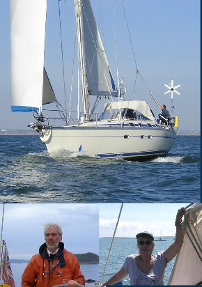
The Boat
MICA is a Bavaria 430 Caribic, 43 ft length overall, built 1992 (one of the earlier and universally recognised as better Bavarias) bought by the present owners as an ex charter yacht in Greece in 1999. She has been a super boat with no significant problems during our eleven years’ ownership. We’ve not seen a boat we like better even brand new at the boat show.
The Ship’s Company
Skipper Mike Ferro and first mate Carole Bradley. Mike has owned boats since the early 1970s, previously a 26 ft Cheverton Crusader and later a 36ft Newman motorsailer.
Route
Starting from Dover we chose to sail clockwise thereby getting the west bound section, most likely to produce windward conditions, done first in familiar waters.
Fuel
This seemed to be a year of calms and gales; everyone we spoke to found the same. We sailed as much as possible but still did a fair bit of motoring and motor sailing to maintain progress and meet tidal deadlines and used around £400’s worth of diesel.
Charts and Pilots
I (Mike) like Admiralty charts. However coverage is not good for sailing round Britain. Leisure editions are not available north of Ardnamurchan Point on the west coast of Scotland and also for much of the east coast north of the Thames Estuary. This means that the more expensive standard editions must be used. Also many charts in the Admiralty coverage are relatively large scale so that a correspondingly large (and expensive) folio of charts must be carried. In consequence Imray charts (which provide good value as they include harbour plans) were mainly used apart from the south coast of England which is well covered by Admiralty home waters leisure editions. Charts and pilots for the latter section were already available on board as we are South Coast sailors. Most of the new charts and pilots for the more northern waters were obtained via internet suppliers prior to setting off. The total cost of charts and pilots, excluding those we already had but including some extra ones we bought during the voyage, came to around £600.
Pilots chosen for Scottish waters were the series published by the Clyde Cruising Club providing coverage from the Isle of Man in the west to Peterhead in the east. This choice was made not on the basis of any preference but out of the mistaken belief that these were the only ones available, as used to be the case. Having since seen alternative pilots covering these waters I would look more carefully at these before making a choice. There are features of the Clyde Cruising Club pilots that I did not like. Many of the harbour plans have limited depth information; contours are shown without indication of what depth is depicted and there are few, and in some cases no, spot depths shown. Also the plans do not show latitude and longitude scales, a serious omission. It should be noted that the Clyde Cruising Club series do not cover the whole of Scotland; the east coast south of Peterhead is not covered by current editions.
No form of electronic charts was carried; all navigation was carried out using paper charts.
Things Learnt Along the Way
Fuel was not always conveniently available; if doing it again unless in a boat of generous tankage I would carry extra fuel in containers (apart that is from the small 25 litres emergency supply we have always carried). Same applies to gas. Calor is generally available but the smaller Camping Gaz bottles not always so.