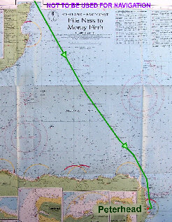
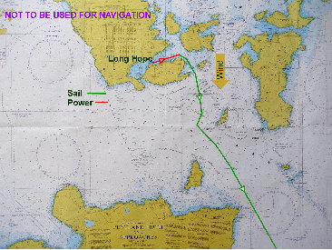
Passage across the Pentland Firth had become a bit of a worry for me but given moderate weather and with careful planning and study of the tidal stream atlas it proved not to be any problem. Whilst in Stromness I had bought a copies of Admiralty chart 2162 covering the Pentland Firth and approaches in detail and also the detailed local Admiralty tidal stream atlas for Orkney and Shetland (available from the Rope Centre chandlery). The Clyde Cruising Club pilot strongly recommends that these be carried (indeed describes them as ‘essential’) and I was certainly pleased to have them on board. My plan was to leave Long Hope around 5 to 6 hours before HW Dover, punch the last of the foul tide down to Cantick Head, the south east point of Hoy, and from there to lay a course midway between Swona and Stroma carrying the early east going stream
17: Hoy to Peterhead, 1st/2nd August
Shipping forecast, 1st August 05.20: Cromarty: W veering NW 3 to 4 increasing 5 at times; showers; mainly good; Fair Isle: NW 3 or 4 occasionally 5; occasional rain; moderate or good, occasionally poor.
through the axis of the strait between these islands and on down to Duncansby Head, the north east point on the Scottish mainland.
Tides were at half springs with HW Dover at 15.20 hours and we left Hoy at 09.40. This worked well enough though there appeared initially to be quite a strong northerly component in the stream, not evident on the tidal charts, which was trying to push us to the north of Swona. There was a good wind from the north however so that sailing goosewinged and steering west of south we could stem this and pass between the two islands as planned. Progress was slow though for a while until we could turn and run with the stream and it might have been quicker to let the tide have its way and take us north around Swona.
Clearing the firth, with Duncansby Head abeam by around midday, we laid course for Rattray Head, distant about 70 miles, and settled down for the remainder of the passage. The wind continued moderate to fresh from the north, the long fetch producing an uncomfortable sea and swell. It was a drear grey day with occasional spells of rain, and sailing with the wind well aft, the boat was subject to a heavy roll throughout the passage. We were pleased finally to make Peterhead and secure to a marina berth (once again plenty to choose from) at 05.30 next morning and turn in for some sleep.
There are those who sneer at Peterhead; we met some of them whilst there (“it’s a dump; who’d want to stay here more than one day?”). True, it’s a busy commercial port with little concession to tourism, but it’s an honest, what-you-see-is-what-you-get sort of place. The town, built of local pink stone, is by no means unattractive, and, well, we liked it.
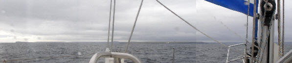
The Pentland Firth: Stroma Island with Swilkie Point light is seen on the port bow, Duncansby Head at left. Note the considerable angle of tidal offset from the track line to Duncansby Head.
NOT TO BE USED FOR NAVIGATION